
Features for planners.
Point‑to‑point certainty for wireless planners.
Evaluate long‑distance wireless links with confidence using meter‑resolution terrain and clutter data, without relying on site visits.

Evaluate long‑distance wireless links with confidence using meter‑resolution terrain and clutter data, without relying on site visits.
Link paths are analysed using meter‑resolution terrain and clutter data.
Point‑to‑point links can be evaluated between assets up to 25 miles apart.
Over 90% of our clutter data used in modelling has been updated in 2024 or later.
Planners can assess line‑of‑sight and link viability without initial site visits.
Understand true link viability before deployment.
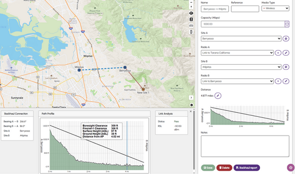
Point‑to‑point links are often critical to network performance and availability. By sampling propagation paths at 1‑meter resolution, WISDM reduces the risk of missed obstructions such as trees or buildings across the full link distance, even over long paths.
Every building and every tree accounted for.
Our point‑to‑point feature uses WISDM’s exclusive Global‑Twin dataset, providing a detailed 3D model of terrain and clutter across the US. This gives planners consistent data quality at a national scale, removing reliance on patchy or outdated third‑party clutter sources.
Compare link options in minutes, not days.
Planners can select any two points, define RF and antenna height parameters, and immediately assess path viability and signal behaviour. This allows rapid comparison of alternative sites, mast heights or frequencies as part of the planning process.
From individual links to full backhaul planning.
Point‑to‑point analysis runs within the wider WISDM platform. Planners can move seamlessly from individual link assessment into coverage modelling, backhaul network design and identifying potential relay or bridge sites where direct paths are not viable.
Point‑to‑point evaluation in WISDM is aimed at reducing uncertainty early in the design process. By improving confidence in link viability before field work begins, planning teams can focus site visits and surveys only where they add real value, rather than using them as a first step.
Accurate office‑based link analysis can limit the need for early‑stage surveys involving drones, mirrors or temporary access to remote sites, helping teams prioritize effort and cost.
Using a single, high‑resolution clutter and terrain dataset supports consistent planning assumptions across regions, supporting large‑scale network design and asset evaluation.
Watch these videos to see WISDM’s intuitive design, powerful modelling capabilities, and installation-ready insights in real time.
Trusted by planning teams across wireless infrastructure.


"We've done more in six months with WISDM than we probably have in the last five years in terms of wireless design."
See how WISDM helps planning teams assess link viability earlier, reduce uncertainty and design more reliable wireless networks.
Book a demo

Please complete the form below with your details.

